

Quiet Weather And Ill-Timed Illness
A brief glance at upcoming severe weather chances, and more reflections on the 2023 severe weather season

Hi friends,
I hope you’re having a great week so far.
This past Saturday was my 38th birthday, which was spent with family and generally taking it easy. I dropped my daughter off for a sleepover that evening and headed off to do some work, only to start having body aches a few hours into my evening.
I hoped I was just experiencing sore muscles from the multiple dance classes I had taken throughout the prior week. However, Sunday morning I woke up with chills to accompany my worsening body aches, and sure enough, I tested positive for COVID-19 (which I assume I acquired in one of those dance classes given they are among my only sources of social interaction during the off-season).
Of course, the “off-season” is a term that’s more hyperbole than anything else. In fact, fall is sometimes referred to as the “second season” for severe weather. Indeed, being a season of transition similar to spring (but usually packing less of a punch), it is not uncommon at all to see severe weather including hail and tornadoes this time of year.
In fact, on my birthday this past Saturday, there were a few tornadoes that occurred across eastern South Dakota in Brookings County (most notably, near the town of Bruce) into far southwestern Minnesota.
Chasing tornadoes sure sounds like a lot more fun than catching Covid.
But here we are.
As I write to you from my “Covid Cave”, as I’ve termed it, I continue to reflect on this past season and look forward to the next one. I’ve recently written a brief recap of my 2023 storm chase season and included snippets of my PNW trip within it (relevant because it precluded me from witnessing a great many prolific storms over that two-week period, but also because it was a grand adventure worth missing storms for).
Before I dig into the harder topics I want to approach in this writing, I want to preface them by expressing that I believe in the importance of practicing an “attitude of gratitude”. I saw many, many beautiful storms this season. I also was able to share in many once-in-a-lifetime moments with guests of my Stormscapes Photo Tours, including their first tornadoes, first lightning bolts captured on camera, and countless gorgeous scenes that would thrill any photographer or weather enthusiast beyond measure.
Additionally, a large publication will be publishing a feature on my tour company in their magazine. I won’t share the publication’s name until the story is in writing, but I’m very excited by the opportunity and by the potential new clientele that this increase in visibility may bring to my doorstep.
For all intents and purposes, my first year in the tour business was very successful, and I am grateful beyond words for that success.
However, there have been major unanticipated setbacks and tough lessons learned along the way, and that is very natural and normal for new businesses. One of the toughest setbacks has been needing to search for a trustworthy new tour guide to assist me as my driver for the 2024 season. But I’ve got several great candidates in mind that I truly believe in to help me carry my vision forward.
And move forward, we must.
Exciting opportunities loom on the horizon. I’ll share them as they evolve.
But for now, I’ll focus on recovery and my various behind-the-scenes work projects. I’m so busy lately, that I virtually work every day from 9 a.m. until midnight with a few short breaks in between, if I’m lucky.
In a weird way, I’m grateful for the rest that COVID has forced me to take, even though it was not a break I could really *afford* to take. It’s needed. We have to make sure we take care of our minds and bodies amidst the daily grind or eventually, our bodies will force us to rest, and it may not be conveniently timed.
Luckily, the “season that never ends” (as I termed it in my prior writing and as I’ve heard it referred to a handful of times within the larger weather community) is indeed taking a bit of a breather from significant severe weather for at least the near term.
I want to point out a few culprits for this pattern shift, as well as some unique features within the larger-scale flow to take note of.
First, check out the 2m temperature anomaly charts per the GFS for this coming Sunday and Monday 10/1 and 10/2 (insert temporary pause to panic that it’s somehow already almost October):


Source: Pivotal Weather, GFS 2 m AGL Temp. Anomaly
For those that don’t know what in the world a temperature anomaly is, it is simply the departure from normal temperature for this time of year. So, these maps are not displaying the forecast temperatures, but rather forecast temperature departures from normal, based on climatology.
The positive (red and orange) numbers indicate warmer-than-normal temperatures for this time of year, and the negative (blue and purple) numbers indicate colder-than-normal temperatures for this time of year.
So, you’ll note a significant portion of the U.S. (basically the entire eastern 2/3 of the country) is forecast to be warmer than normal for this time of year by a good 10 to 20°F particularly across the Upper Midwest.
Why is that?
Check out the 500mb heights for 7:00 p.m. CDT on Sunday and Monday evenings (the first two images below), again per the GFS. The third image is for Tuesday at 1:00 a.m. CDT. You’ll see that there is a large upper trough centered over NW Nevada and the Great Basin, while an upper ridge dominates the pattern further east.
A ridge in the upper levels means subsiding (sinking) air that suppresses storm activity and promotes warmer temperatures for the eastern 2/3 of the U.S. It also inhibits any appreciable moisture return.
But watch the evolution of that upper low as it slowly translates eastward (or if this all sounds like Greek to you, feel free to skip to the end for the TL;DR):
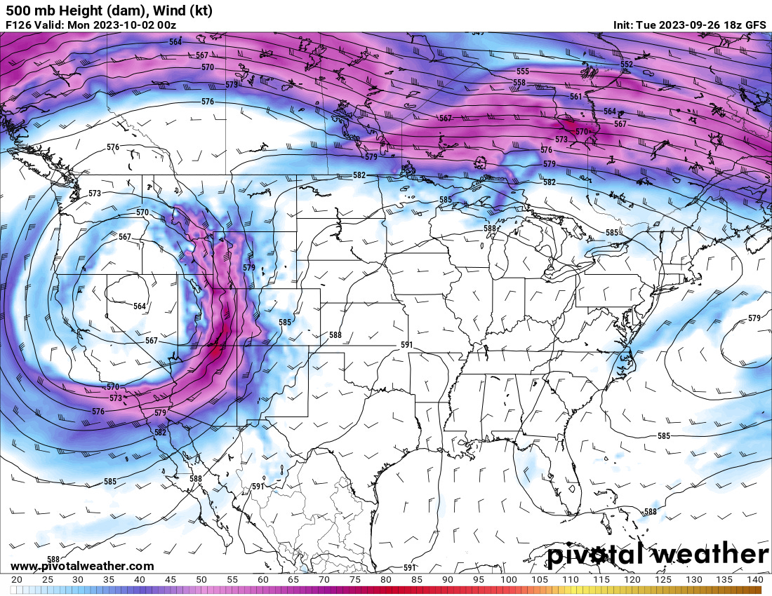

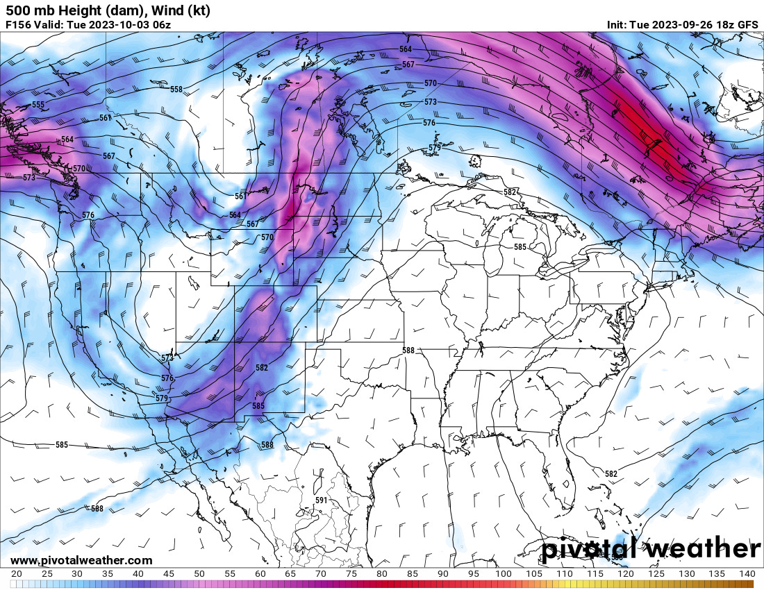
Source: Pivotal Weather, GFS 500mb Height (dam), Wind (kt)
Did you see what happened? The low appears to split into two separate cutoff lows. Keep in mind, this is one run of the GFS, but I still nerd out when I see unique system evolutions. But we’ll have to watch and see how it plays out.
Those unseasonably warm temperatures could yield pockets of moderate instability across the Upper Midwest and Northern Plains through the weekend. However, overall dynamics appear to be weak, precluding a widespread severe weather threat (at this time), so I’m not really expecting much out of it. But I’ll be keeping my eyes open as we get closer to these events to see if anything pops up worth discussing.
The TL;DR: Much of the eastern and central U.S. will see warmer than average temperatures through at least Tuesday of next week, while some stormy weather (including possible snow for the higher elevations further west) is possible in association with the troughs (or split flow) as they move across the western U.S. Scattered strong to isolated severe storms may be possible across the Northern Plains and Upper Mississippi Valley over the weekend. There are details still to be ironed out.
That’s enough forecast talk for tonight. I need to rest and recharge, hoping for a fast recovery so I can begin to pick up on the slack of the work I’ve missed these last few days. That’s one of the few downsides of working for yourself, you’ve got no one to cover you during sick days, and no PTO, so the quicker I can get back at it, the better.
I hope everyone has a great rest of your week! 🌪️
~ Jess
P.S., And now, here’s a little something for my paid subscribers… (see below)
Keep reading with a 7-day free trial
Subscribe to Twisted Pixels to keep reading this post and get 7 days of free access to the full post archives.