

Significant Severe Weather Today, 2/26
Derecho and strong EF2/3+ tornadoes possible in Central/Southern Plains

Well, today’s forecast is a doozy.
I’ve been watching this system - as well as the next incoming system this Thursday - for days now.
I’d mentioned that I thought today might be my first chase of the season; unfortunately, due to logistical factors, it won’t be possible.
However, I promised a forecast breakdown for today, so I’ll be armchair chasing this system and providing some insight below.
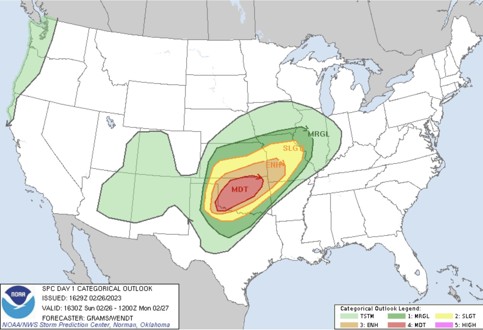
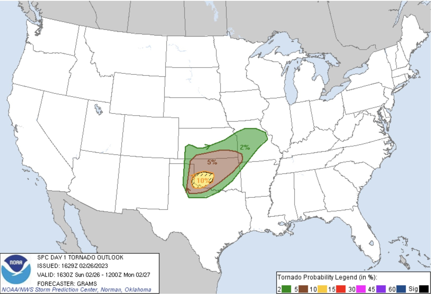
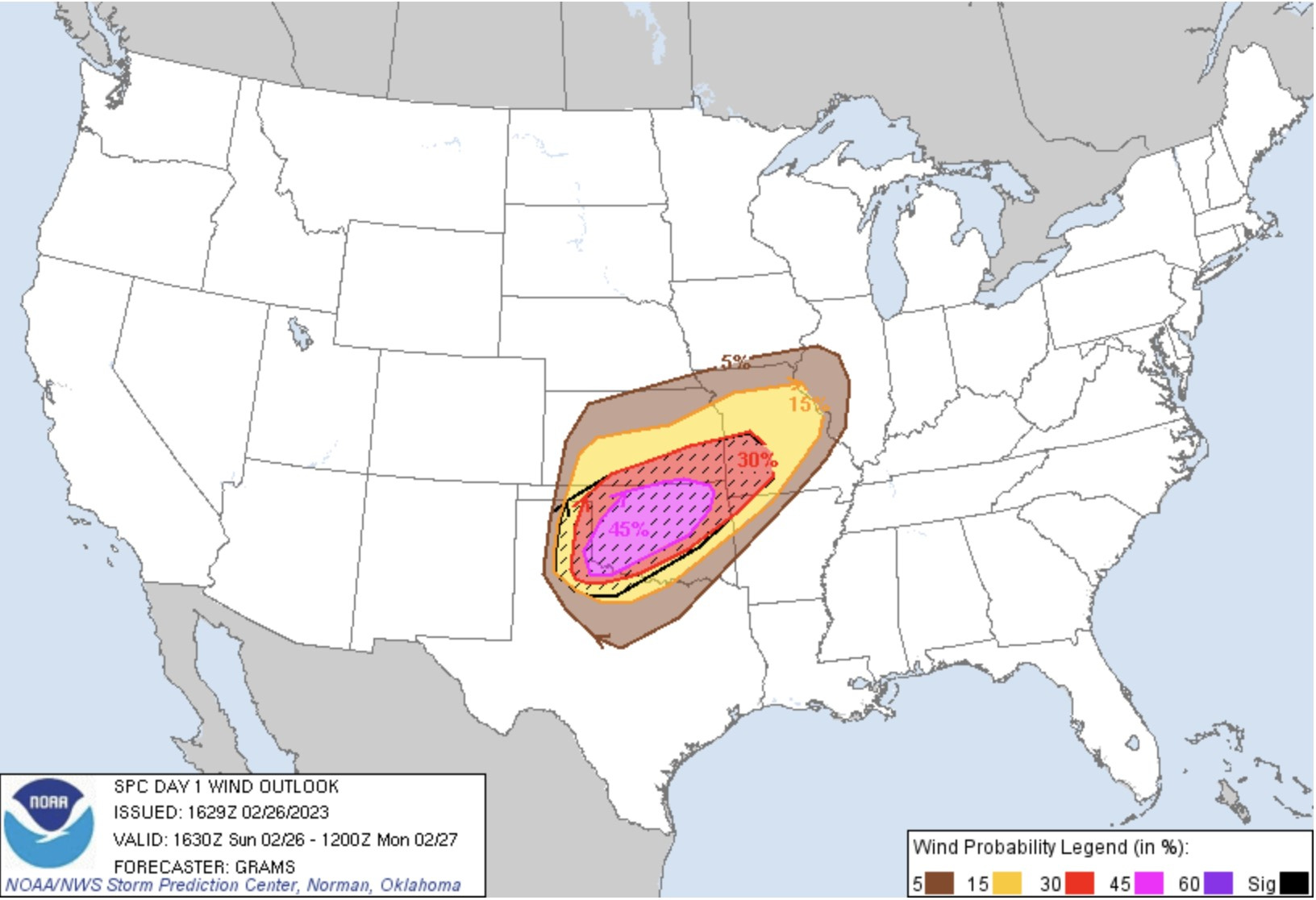
Source: NOAA/NWS Storm Prediction Center
I’m not going to regurgitate the SPC’s forecast, you can read it in depth by following the credit link above; however, these graphics give a good visual of the severe threats that are expected today.
These images represent today’s Day 1 outlooks for convective probabilities (moderate risk over west/central OK), tornado risk (10% hatched risk area over southwest Oklahoma/far eastern TX panhandle), and wind risk, and this is a big deal for Oklahoma today: a 45% hatched risk and a prediction for a significant wind event, termed a derecho, across much Oklahoma today.
What is a derecho? A derecho is a widespread, long-lived windstorm that is associated with a line of convective storms such as a mesoscale convective system (MCS) or a quasi-linear convective system (QLCS).
But initially, semi-isolated storms that develop in the eastern Texas panhandle into southwestern/western Oklahoma have the potential to produce large hail, damaging winds, and strong tornadoes before the whole system grows rapidly upscale into a likely derecho.
Let’s look at the 17z HRRR (High Resolution Rapid Refresh) prediction of today’s convective evolution:

Source: COD Composite Reflectivity Factor (dBZ) valid time: 00z/6 pm CST
The HRRR is depicting an initially semi-discreet line of storms tracking from southwest Kansas southward into the eastern Texas panhandle at 6 pm CST. The black lines around the darker red reflectivity values indicate helicity tracks (indicating more potential for rotation) in association with these storms. These initial storms appear to have the most potential to produce more isolated, strong tornadoes.
If I were chasing, I’d position myself somewhere around Shamrock to McLean, Texas, and play the southernmost strongest storms. From there I could move north/south as needed before blasting east to try to stay ahead of very fast-moving storms. It won’t take long, maybe a few hours at most, before these storms congeal into an intense line of storms racing eastward and producing isolated straight-line wind gusts from 80-110mph! This is where chasing becomes dangerous, though. If chasers can’t stay ahead of this line, they risk being engulfed by it and its incredibly strong winds and possibly strong tornadoes.

Source: COD Composite Reflectivity Factor (dBZ) valid time: 05z/11 pm CST
As we approach the midnight hour, a long line of very intense storms producing very damaging winds, including embedded strong tornadoes, is possible and even likely across southern Kansas into central Oklahoma. The eastward extent of this likely derecho remains unclear given the uncertainty in the quality/depth of moisture return further east.
But all of Oklahoma needs to be on alert for this possible derecho/significant severe wind event today. Secure any loose items outside your home. Be prepared for possible power outages with downed powerlines. This event is a big deal.
It is critical to have a way to receive weather alerts, such as a NOAA weather radio, your local media stations, alerts on your phone, etc. The more ways you have to receive weather alerts the better. Take all warnings seriously and seek shelter immediately if any tornado warnings are issued for your area.
I’ll be watching how this event plays out from home. Storm initiation will likely begin between 4 and 5 pm CST. I’m hoping I don’t miss any incredible tornadoes today, but more than anything, I’m concerned for residents in the path of these storms. I hope that everyone - chasers and locals alike - remains safe out there today.
I’m a bit back and forth about these forecast discussions and I think it may be best for me to have them continue to be free for my subscribers. I’ll leave free downloads of my images and other perks for my paying subscribers, but it just doesn’t feel right to charge for my forecast discussions when I want everyone to have the information. So for now they will remain free.
Additionally, I’m looking at a very potent system on Thursday as my first actual chase of the year. Check out this potent trough ejecting over the southern plains into southern Dixie Alley Thursday:

Source: Pivotal Weather 12z GFS 500mb Height (dam), Wind (kt)
I’m eyeing eastern Texas into southern Dixie for my first chase of the season this Thursday. It’s still several days out, but I’m watching each new model run of the Euro and GFS like a hawk. The Euro (ECMWF) was onto this system as far back as Thursday, but GFS took a few days to catch up. The SPC has issued a fairly rare Day 5 enhanced risk over eastern Texas into the Gulf Coast states:

Source: NOAA/NWS Storm Prediction Center Day 5 Severe Weather Outlook
I’ll be watching trends, charging up all my gear, clearing the memory cards, and making all the necessary preparations for this week’s likely chase. I’ve got to do some last-minute fixings with my car. My brake light is out, my tires need balancing/rotation, and my brakes in general need to be checked. I also need to test my livestreaming equipment and other last-minute checks. Lots to do, especially as I wasn’t quite prepared to begin my chase season so early.
I’m also going to go ahead and offer my first free digital download to my paid subscribers below, as a thank you for your support of my written content. It really means so much! It’s also never too late to become a paid subscriber, and thank you so much in advance.
Keep reading with a 7-day free trial
Subscribe to Twisted Pixels to keep reading this post and get 7 days of free access to the full post archives.